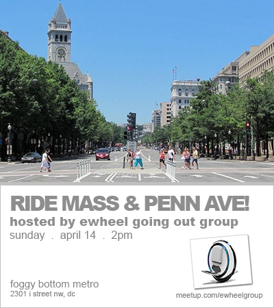
Ride Massachusetts & Pennsylvania Avenue! – eWheel Going Out Group
.
< Click here to go back to RSVP page
*** It’s a great day for an ewheel ride. See you there! ***
UPDATE #2: The email with my cell no. has been sent to the yes RSVPs. TEXT me if you need to. If you do not see my email, check your spam folder, and also make sure your email and Meetup settings allow for you to always receive messages from the organizer. If it’s not there, send me a message through my Meetup profile with YOUR CELL NO. so I can text you back. See you there!
UPDATE #1: Weather.com is currently forecasting temperatures in the mid 70s with a small 15% chance of rain for the duration of our ride (or from a glass half full perspective, an 85% chance of NO RAIN), for our location’s zip code. Per the “Rain Policy” section of the full event description, this event is a “go.” See you there!
—
Let’s get together for our next ride!
Riders from previous Meetups (Aian Neil, Anibal, Ben, Brandon, Chris, Dave, Edwin, Erwin, Haitao, Heather, James, Jeff, Jessica, Joe, John, Jonathan, Kevin, Kris, LeRoy, Loren, Lutalo, Mark, Megan, Melissa, Michael, Nick, Phil, Rakesh, Raul, Richard, Robert, Rodney, Shelly, and Steven), come join us again! New riders, come join us for the first time!
We’ll ride Massachusetts and Pennsylvania Avenue and stop numerous times along the way to enjoy the sites, memorials, landmarks, and to also let some of the slower riders catch up (if some of us decide to go at a quicker speed). Ideally, we will all ride together and at the same speed, but that may or may not be possible with other pedestrians, bicyclists, etc. sharing the same paths, but let’s do our best please! In total, it’s an ~8.5 mile trip that’s sure to be enjoyable!
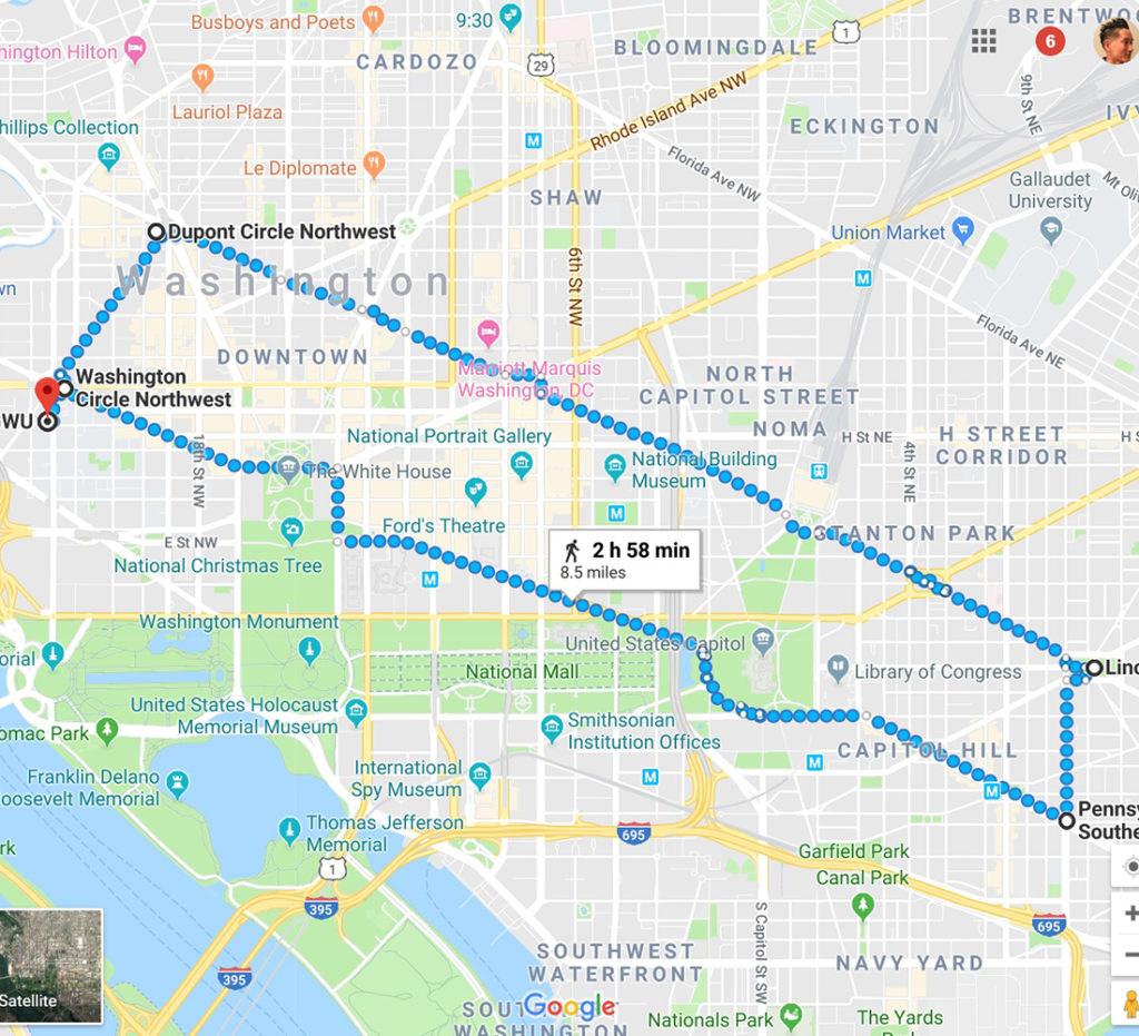
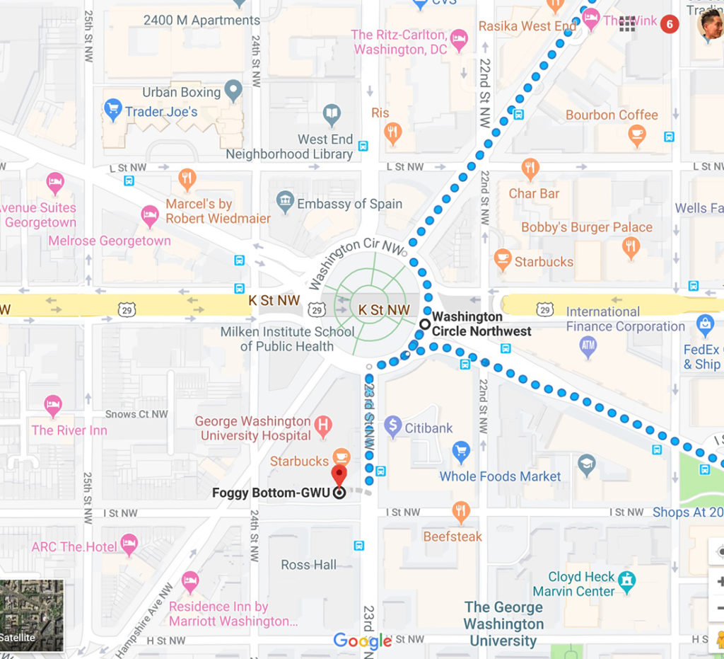
We’ll meet up at the Foggy Bottom Metro at 2pm. Then we’ll ride north on 23rd Street NW for 0.1 miles to Washington Circle, at 2:30pm.
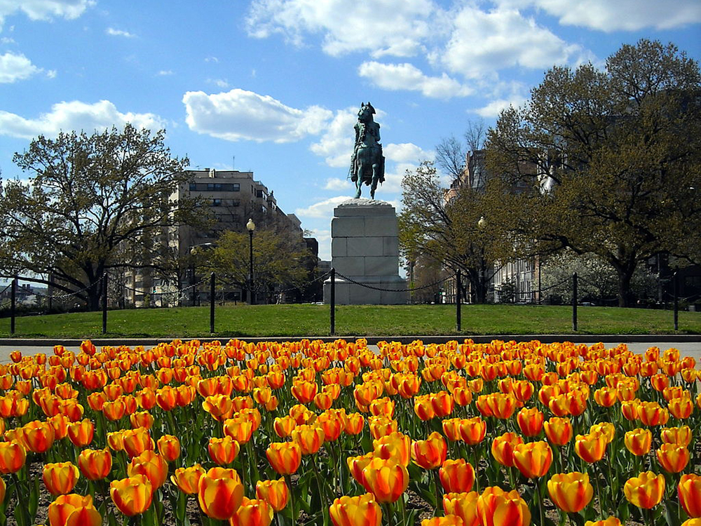
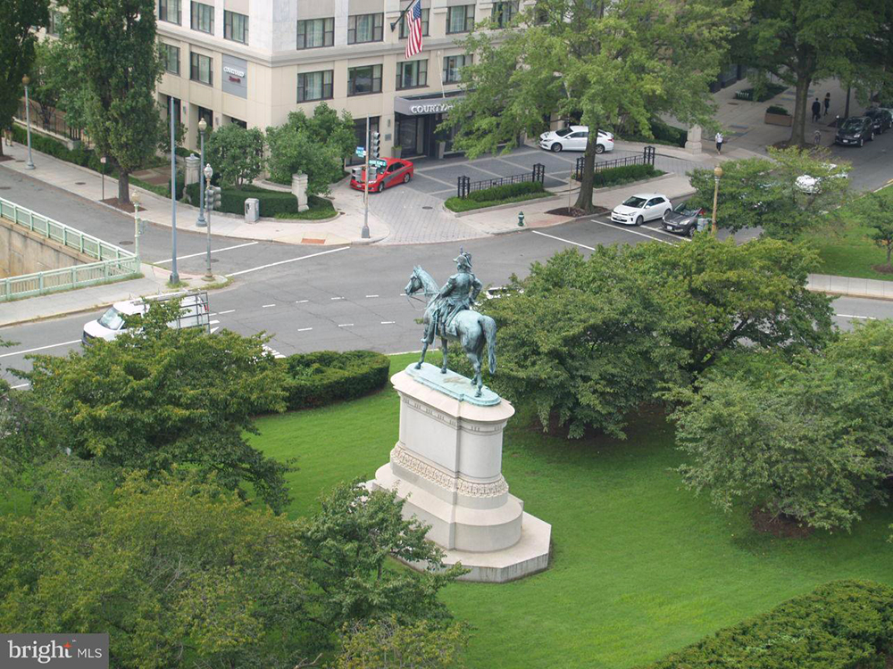
Washington Circle is a traffic circle located on the border of the Foggy Bottom and West End neighborhoods (Ward 2 section). The through lanes of K Street (Route 29) travel underneath the circle in a tunnel, while the service lanes intersect the circle. A bronze equestrian statue, sculpted by Clark Mills and depicting George Washington riding his horse during the Battle of Princeton, was installed in the center of the circle on February 22, 1860. The Continental Congress voted to build the statue in George Washington’s honor in 1783 but the statue was not commissioned until 1853 at a total cost of $60,000. Mills depicted General Washington in the heroic, idealized Romantic style, reminiscent of Jacques-Louis David’s painting Napoleon Crossing the Alps. Washington’s horse was modeled on a wild horse that was captured on the plains of Kansas. The National Park Service now maintains Washington Circle’s park, the public space surrounding Washington’s statue.
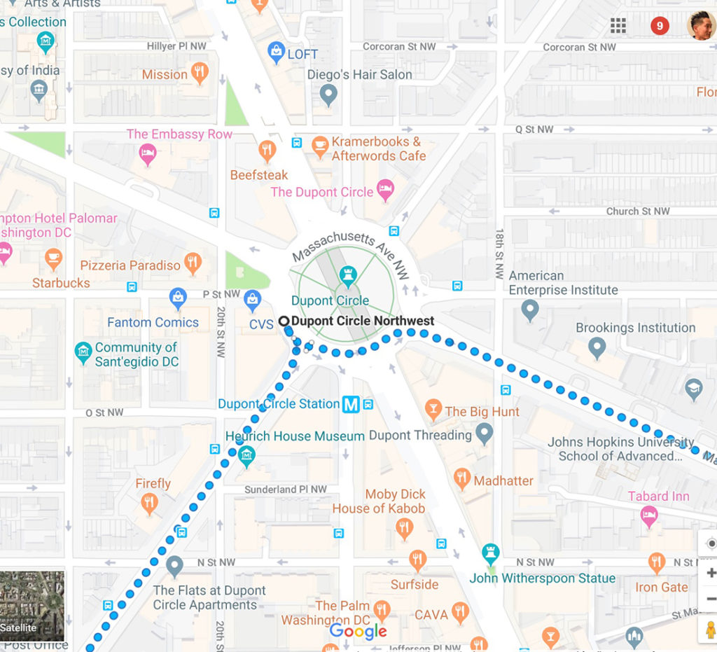
From Washington Circle, we’ll head northeast on New Hampshire Ave NW for 0.6 miles to Dupont Circle.
Dupont Circle is a traffic circle, park, neighborhood, and historic district. The neighborhood is centered around the traffic circle, which is divided between two counterclockwise roads. The outer road serves all the intersecting streets, while access to the inner road is limited to through traffic on Massachusetts Avenue.
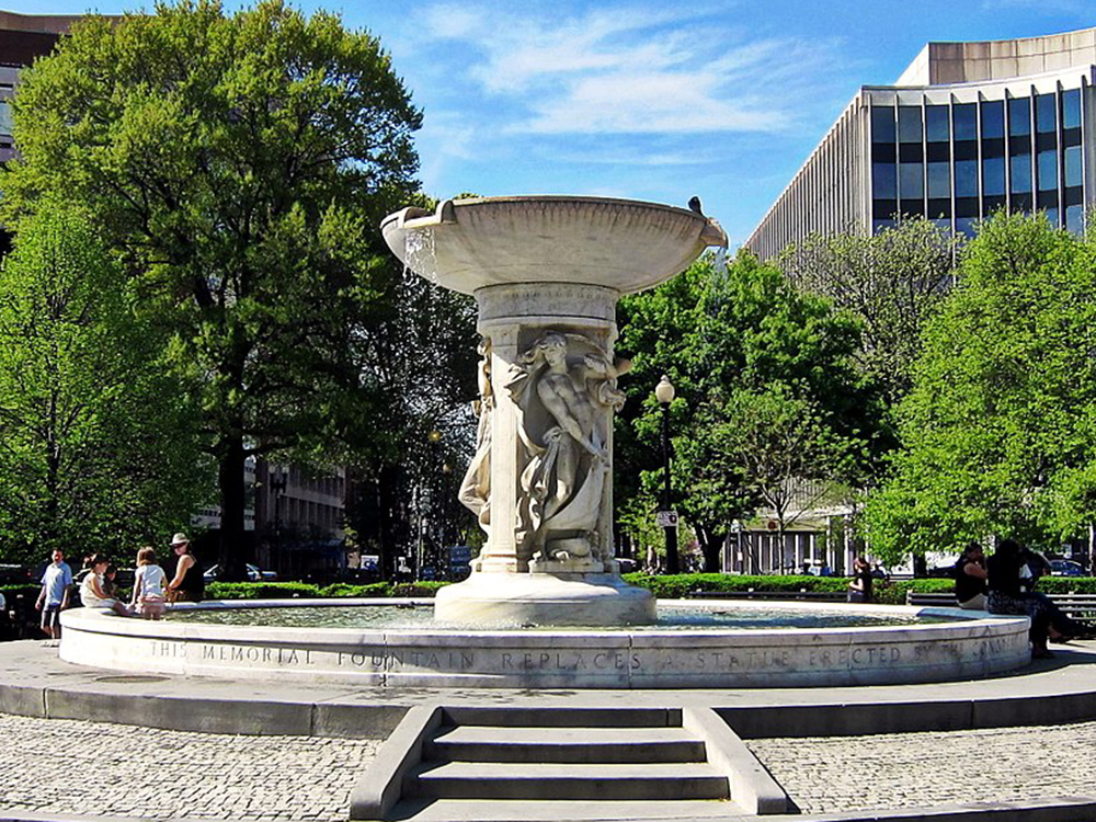
The Dupont Circle fountain was designed by Henry Bacon and sculpted by Daniel Chester French. The marble fountain is in honor of Rear Admiral Samuel Francis Du Pont. The fountain’s shaft features carvings of three classical nudes symbolizing the sea, the stars, and the wind. The central fountain provides seating, and long, curved benches around the central area were installed in 1964. The park within the circle is a gathering place for those wishing to play chess on the permanent stone chessboards. Tom Murphy, a homeless championship chess player, is a resident. The park has also been the location of political rallies, such as those supporting gay rights and those protesting the 2003 invasion of Iraq, the World Bank, and the International Monetary Fund.
From Dupont Circle, we’ll head southeast on Massachusetts Avenue for 0.4 miles.
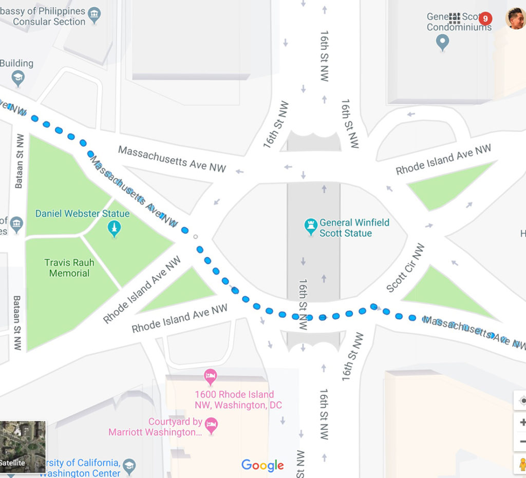
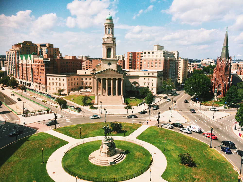
Next, we’ll come across Scott Circle. The embassies of Australia and the Philippines are located on Scott Circle, as is the University of California, Washington Center, and the General Scott Condominiums. A sculpture of General Winfield Scott was erected in Scott Circle in 1874. The Daniel Webster Memorial and Samuel Hahnemann Monument can be found on the periphery of the circle.
General Winfield Scott is an equestrian statue that honors career military officer Winfield Scott. It was the first of many sculptures honoring Civil War generals that were installed in DC’s traffic circles and squares. The sculpture is one of the city’s 18 Civil War monuments that were collectively listed on the National Register of Historic Places in 1978. The bronze statue rests on a granite base that at the time was the largest stone ever quarried in the United States. Much criticized for its depiction of Scott and the proportions of the horse, it is considered one of the worst equestrian sculptures in the city by authors and historians.
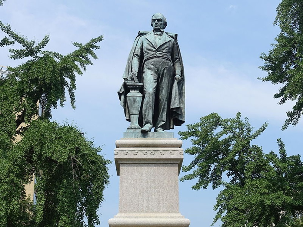
The Daniel Webster Memorial is a monument honoring U.S. statesman Daniel Webster. It is located near Webster’s former home at 1603 Massachusetts Avenue, beside Scott Circle at the intersection of Massachusetts Avenue and Rhode Island Avenue. The statue of Webster was given to the United States government by Stilson Hutchins, founder of the Washington Post and a fellow native of New Hampshire. The Daniel Webster Memorial consists of a 12-foot bronze statue of Webster on an 18-foot granite pedestal in a sober classical style. On the east and west sides of the pedestal are bronze bas-relief panels illustrating events in Webster’s life: the Webster–Hayne debate; the dedication of the Bunker Hill Monument.
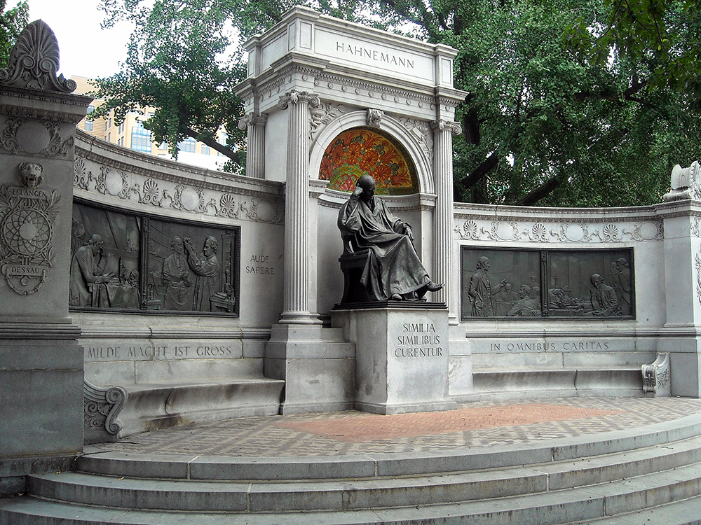
The Samuel Hahnemann Monument is a public artwork dedicated to the founder of homeopathy. It is located on the east side of Scott Circle. The monument is significant because Hahnemann is the first foreigner not associated with the American Revolution to be honored with a sculpture in DC. The monument was dedicated in 1900. Among the thousands of attendees at the dedication ceremony were prominent citizens including President William McKinley, Attorney General John W. Griggs, and General John Moulder Wilson. The monument was rededicated in 2000 and a restoration process was completed in 2011. It was listed on the National Register of Historic Places in 2007.
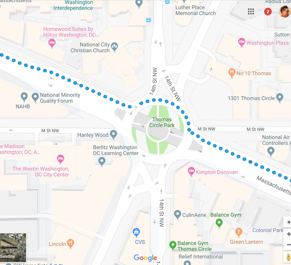
From Scott Circle, we’ll continue southeast on Massachusetts Avenue for 0.3 miles to Thomas Circle.
Thomas Circle is a traffic circle named for George Henry Thomas, a Union Army general in the American Civil War. In October 2006, the DC Department of Transportation completed a 2.5-year, $6 million reconstruction of the Thomas Circle. The project included the addition of bike lanes, pedestrian crosswalks mid-circle (which hadn’t previously existed), new in-circle traffic lights, better street lighting, and new sidewalks and landscaping. The rehabilitation of Thomas Circle won an Honorable Mention in the “Historic Preservation” category of the Federal Highway Administration’s Excellence in Highway Design awards for 2006. The circle marks the boundary between “downtown 14th Street” and the “uptown 14th Street”, the latter of which is a rapidly gentrifying gay neighborhood within the city. D.C. city officials now consider Thomas Circle to be a “gateway” to the Logan Circle, Shaw, and U Street Corridor neighborhoods.
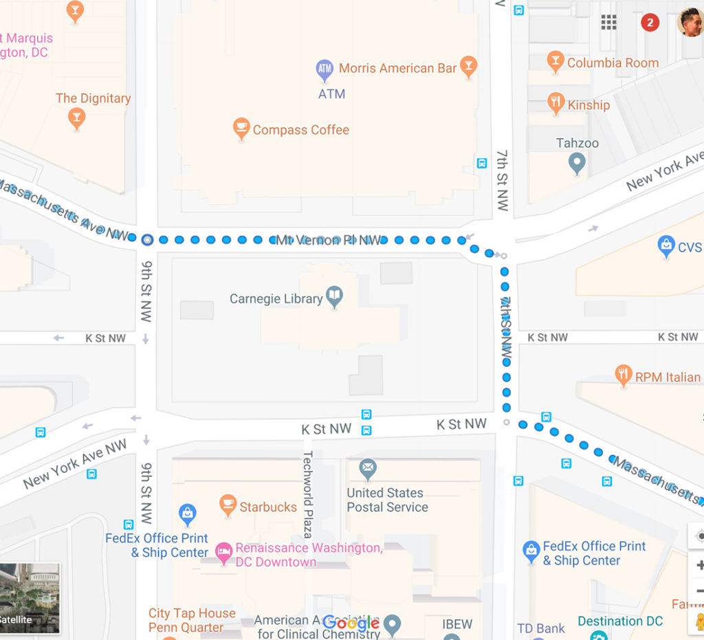
From Thomas Circle, we’ll continue southeast on Massachusetts Avenue for 0.5 miles to Mt. Vernon Square, where we’ll make a left on Mt. Vernon Place NW and then an immediate right onto 7th Street NW before turning left back onto Massachusetts Avenue.
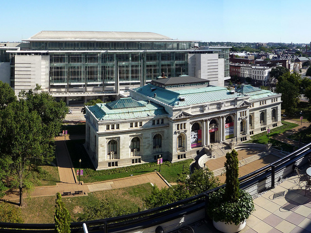
The Carnegie Library, also known as Central Public Library, is situated in Mount Vernon Square. Donated to the public by entrepreneur Andrew Carnegie, it was dedicated on January 7, 1903. It was the first Carnegie library in DC and the first public library. It was also DC’s first desegregated public building. It was used as the central public library for D.C. for almost 70 years before it became overcrowded. The central library was then moved to Martin Luther King Jr. Memorial Library. After being shut down for ten years it was renovated as part of the University of the District of Columbia. In 1999, it became the headquarters for the Historical Society of Washington, D.C. In September 2016, Apple Inc. proposed renovating the library into DC’s second Apple Store location. In December 2016, Events DC announced an agreement with the company for conversion of the space into a new store designed by Foster and Partners.
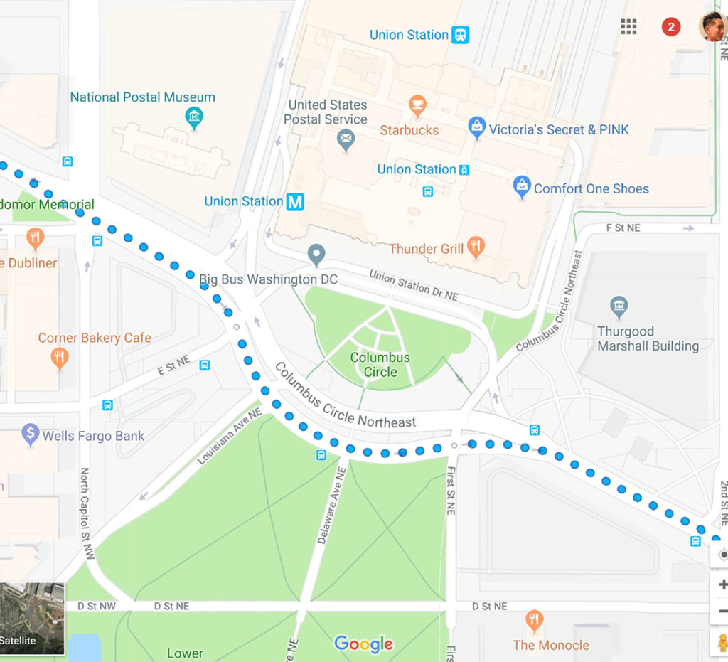
From Mt. Vernon Square, we’ll continue southeast 1 mile on Massachusetts Ave to Columbus Circle.
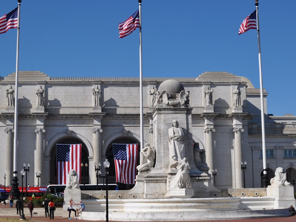
Columbus Circle, also known as Union Station Plaza or Columbus Plaza, is located in front of Union Station right next to the grounds of the United States Capitol. The centerpiece of the circle is the Columbus Fountain, flanked by three 110 ft flagpoles. It was unveiled on June 8, 1912 in a three-day celebration involving tens of thousands of people. Parades, concerts and fireworks drew citizens of the city. This is when the plaza started to be called Columbus Circle due to the monument present in its center. Two small fountains on each side of the Columbus Fountain frame the circle along with several stone balustrades. The circle is ringed by flags of each of the 50 U.S. states in order of admission to the Union plus the flags of the U.S. territories and the District of Columbia.
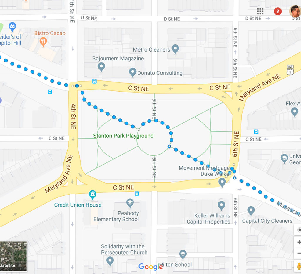
From Columbus Circle, we’ll continue southeast 0.3 miles on Massachusetts Avenue to Stanton Park.
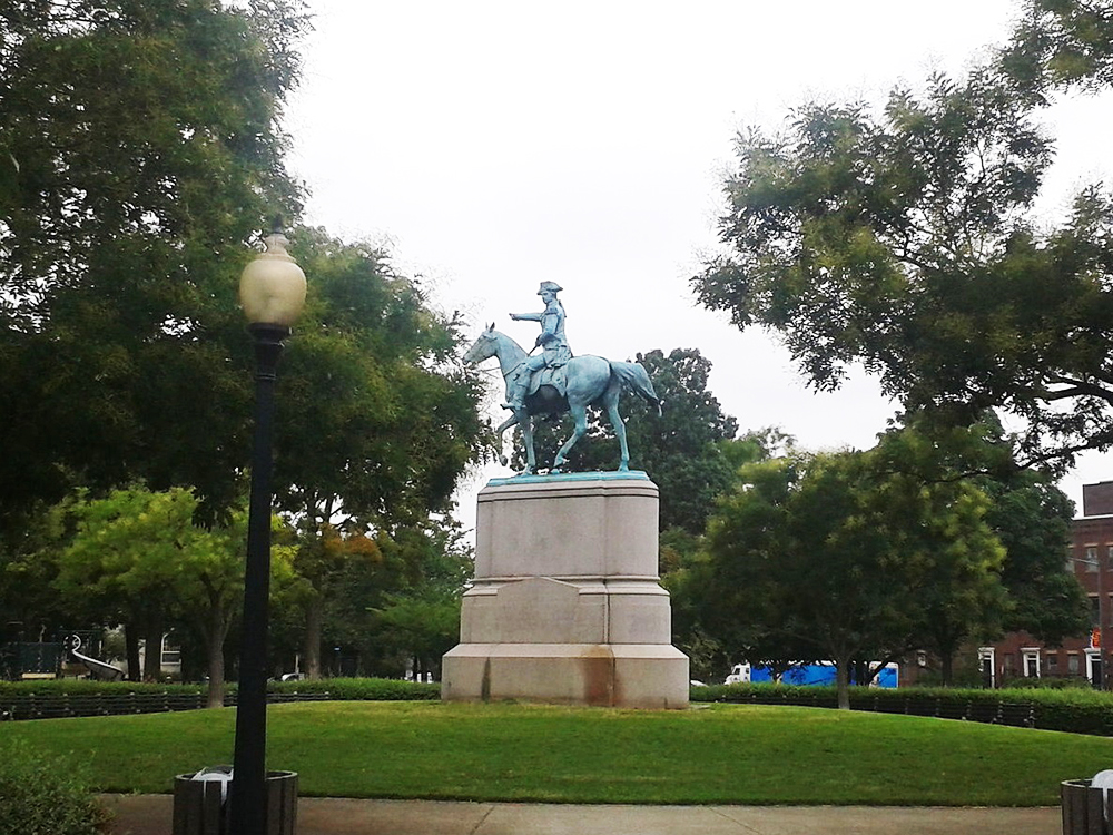
Stanton Park preiously known as Stanton Square is a national park located in the Capitol Hill neighborhood. The park is named after Edwin M. Stanton, the United States Secretary of War during the American Civil War, whose attempted later removal prompted the impeachment of President Andrew Johnson. Located in the center of Stanton Park is a statue of American Revolutionary War Major General Nathanael Greene. The park was included in Pierre L’Enfant’s original plan for the city. A playground is located in the western section of the park; a section in the eastern half is often used by dog walkers. The park is maintained by the National Park Service and as such, dogs are not allowed off-leash. “Stanton Park” is also commonly used to describe the surrounding neighborhood.
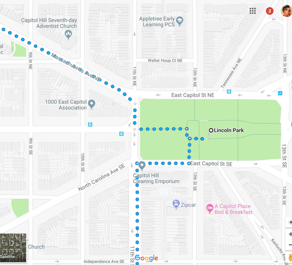
From Stanton Park, we’ll continue southeast on Massachusetts Ave for 0.5 miles to Lincoln Park.
Lincoln Park is the largest urban park located in the Capitol Hill neighborhood. From 1862 to 1865, it was the site of the largest hospital in DC: Lincoln Hospital. Situated one mile directly east of the United States Capitol, the eastern end of the park includes two separate, enclosed play areas for young children. The grassy perimeter and central turf area are popular with neighborhood dogs and their owners. Though it was originally planned as the point from which all distances in North America would be measured, it was not ultimately utilized for this purpose.
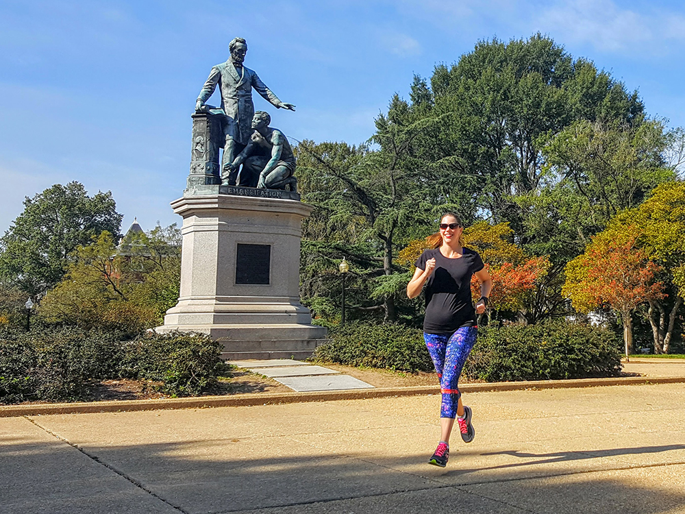
The park features two important sculptures: Thomas Ball’s 1876 Freedman’s Memorial to Abraham Lincoln (Emancipation Monument), one of the first memorials in DC honoring Abraham Lincoln. It was dedicated on April 14, 1876 with an oration by Frederick Douglass. the monument depicts Abraham Lincoln in his role of the “Great Emancipator” freeing a male African American slave modeled on Archer Alexander.
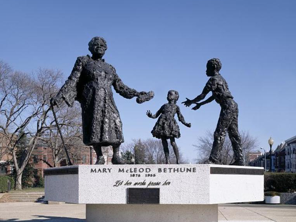
Robert Berks’s statue of Mary McLeod Bethune, an educator and activist. It was unveiled on the anniversary of her 99th birthday, July 10, 1974, before a crowd of over 18,000 people. The monument is the first statue erected on public land in DC to honor an African American and a woman. The statue features an elderly Mrs. Bethune handing a copy of her legacy to two young black children. Mrs. Bethune is supporting herself by a cane given to her by President Franklin D. Roosevelt.
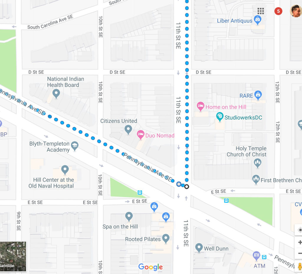
From Lincoln Park, we’ll travel south on 11th Street SE for 0.5 miles to Pennsylvania Avenue.
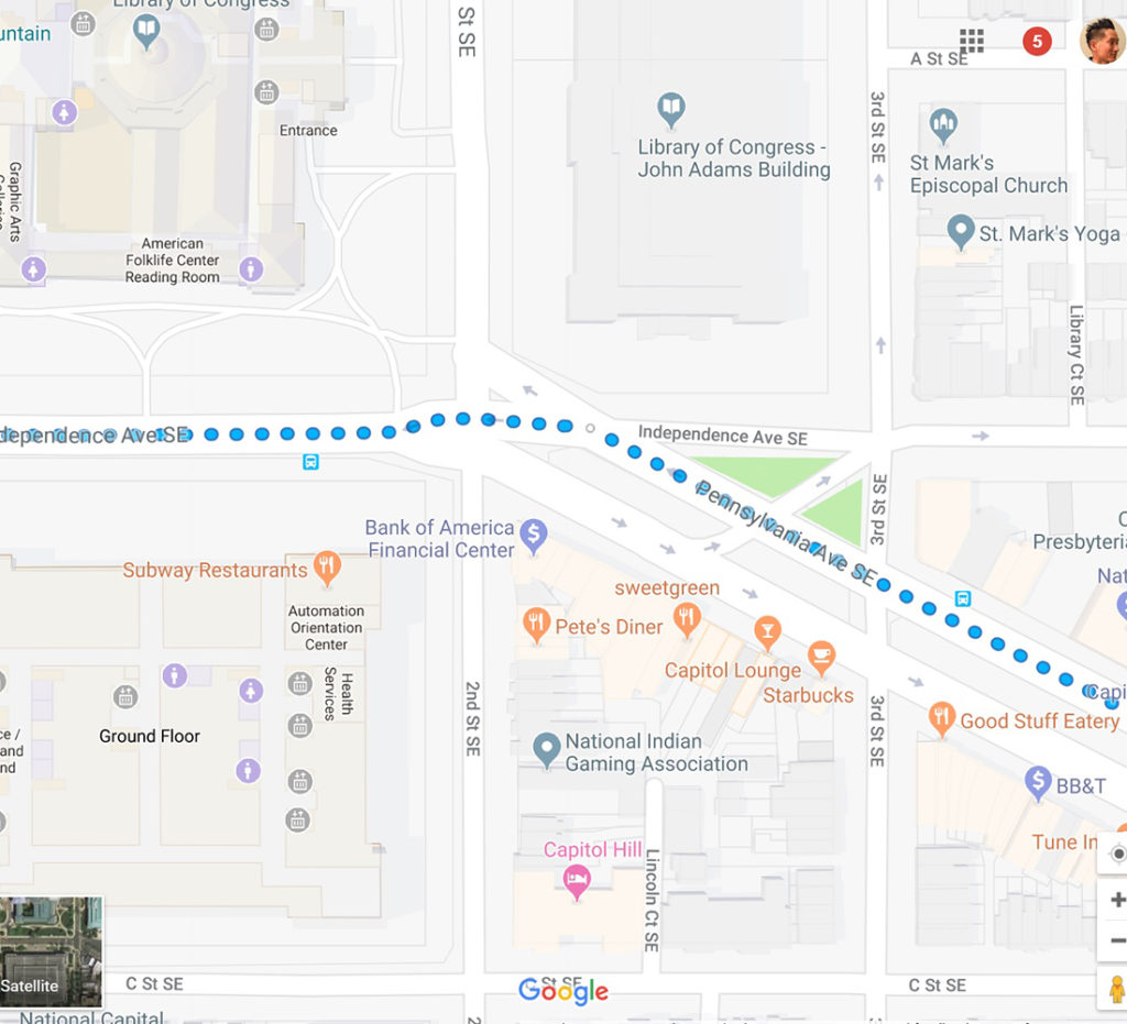
We’ll then travel 0.7 miles on Pennsylvania Avenue and then veer left on Independence Avenue for 0.3 miles.
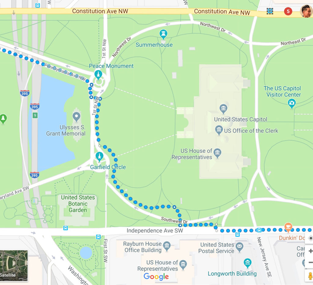
We’ll then veer right around the US Capitol before getting back on Pennsylvania Avenue.
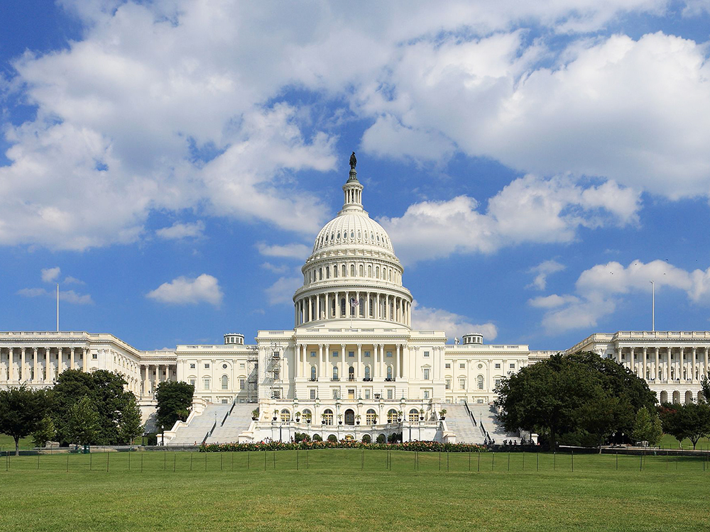
The United States Capitol, often called the Capitol Building, is the home of the United States Congress and the seat of the legislative branch of the U.S. federal government. It is located on Capitol Hill at the eastern end of the National Mall. Though no longer at the geographic center of the Federal District, the Capitol forms the origin point for the District’s street-numbering system and the District’s four quadrants. The original building was completed in 1800 and was subsequently expanded, particularly with the addition of the massive dome, and expanded chambers for the bicameral legislature, the House of Representatives in the south wing and the Senate in the north wing. Both its east and west elevations are formally referred to as fronts, though only the east front was intended for the reception of visitors and dignitaries.
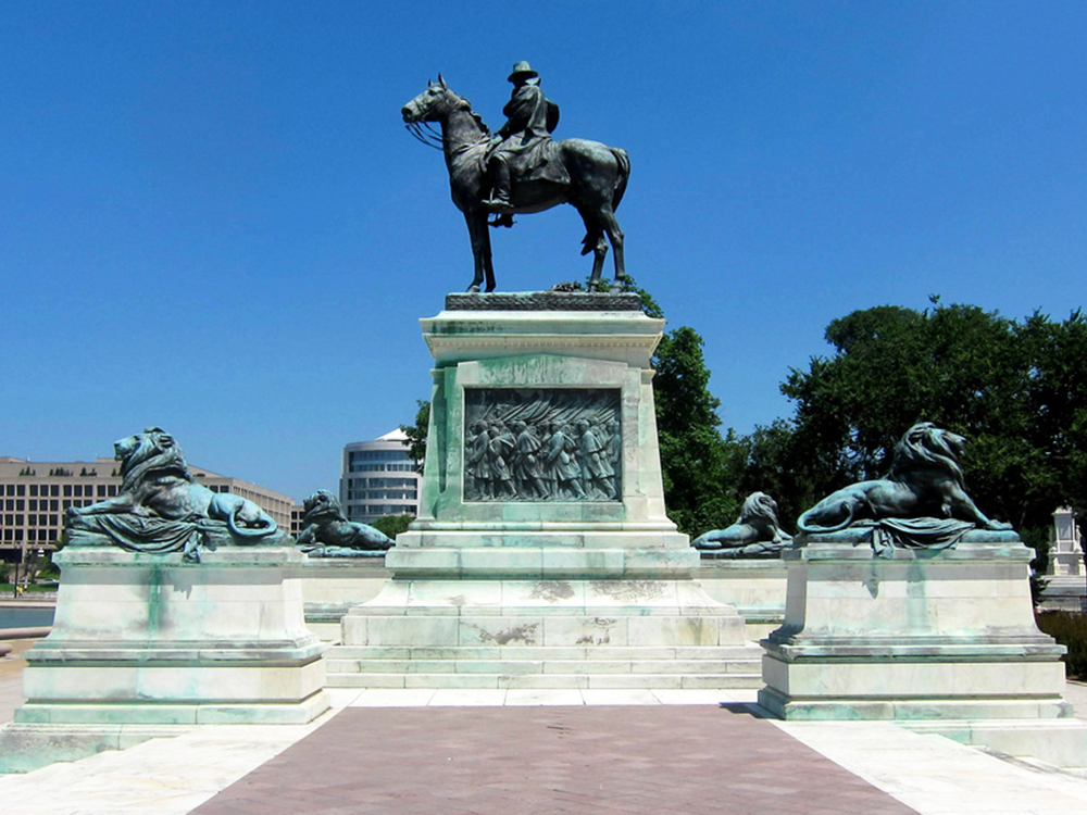
In front of the Capitol is the Ulysses S. Grant Memorial, honoring American Civil War general and the 18th US President. Its sculpture of Grant on horseback faces west, overlooking the Capitol Reflecting Pool and facing toward the Lincoln Memorial, which honors Grant’s wartime president, Abraham Lincoln. The Grant and Lincoln memorials define the eastern and western ends, respectively, of the National Mall. It includes the second-largest equestrian statue in the United States and the fourth-largest in the world.
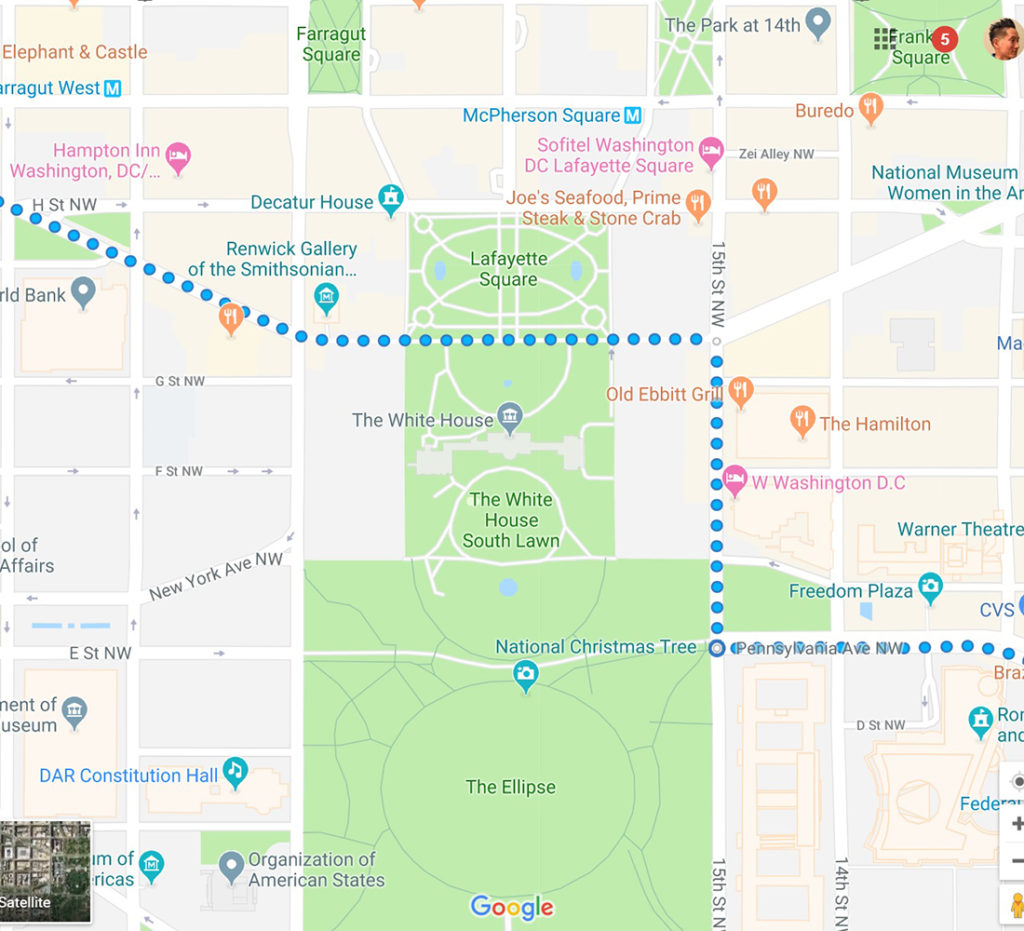
Next, we’ll head northwest on Pennsylvania Avenue for 1.3 miles to 15th Street NW, where we’ll make a right and travel for 0.2 miles before we make a left to get back on Pennsylvania.
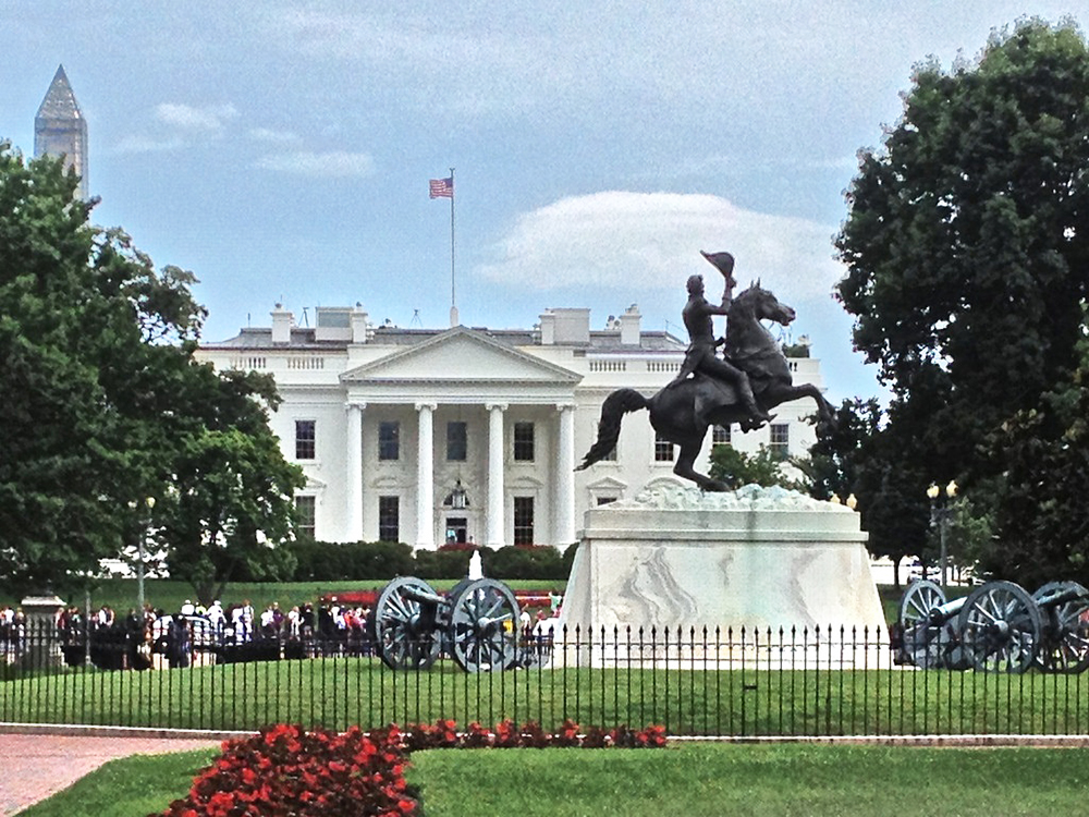
Along the way, we’ll stop by the White House and Lafayette Square. The White House is the official residence and principal workplace of the President of the United States, located at 1600 Pennsylvania Avenue NW in Washington, D.C. It has been the residence of every U.S. president since John Adams in 1800. The term White House is often used to refer to actions of the president and his advisers, as in “The White House announced that…”
We’ll also pass by Lafayette Square, a seven-acre public park located within President’s Park, directly north of the White House. It is named for the Marquis de Lafayette, a hero of the American Revolution, and includes a prominent statue of early 19th century President and general Andrew Jackson on horseback. The square and the surrounding structures were designated a National Historic Landmark District in 1970.
From the White House, we’ll travel another 1 mile back to Washington Circle, then another 0.1 miles back to Foggy Bottom Metro.
Come join us as we spend an afternoon together exploring the sites, memorials, and landmarks Massachusetts and Pennsylvania Avenue have to offer! Please also help spread the word of our group and event, especially since this is relatively new technology and we are a small community!
I look forward to seeing you there!
– J.T.
—
METRO & PARKING
We’ll meet at the Foggy Bottom Metro (Orange, Blue, Silver lines). I suggest Metro / cabbing / Uber’ing if you can. I also recommend using wmata.com for travel planning. Don’t forget to account for Metro, traffic, and parking delays. If you are driving, you will need to find street parking or a garage. I recommend using parkopedia.com for garage parking planning.
DRESS
Please dress appropriately for the weather. For those with problems having their feet go numb or tired during long rides, I recommend wearing shoes with a stiff and flat sole.
RIDING ETIQUETTE
Since e-wheels are relatively new technology, please be as courteous as possible to other pedestrians, bicyclists, etc. Being new, riding etiquette is not something that’s really been quite established. However, based on personal experience (I’ve been riding daily since 2015), I’ve noticed some general good practices and rules to follow. 1) ALWAYS give pedestrians the right of way. 2) When riding on a narrow sidewalk, and you’re coming up behind a pedestrian and you need to pass them, either a) wait until there’s an opening, or b) clear your throat and say “excuse me” in a *gentle* manner (I’ve noticed people tend to get startled / surprised when they see and hear a tall figure behind them on a wheel) before passing them. 3) SLOW DOWN to a pedestrian’s walking pace (until you are completely clear of them) whenever approaching or passing (whichever direction they are walking). Only after passing a pedestrian for a little distance is it a good idea to go faster than walking pace. Whatever you do, please do NOT wiz by them. 4) Thank the pedestrian as you are passing. 5) Slow down as you are going around a turn (whether there are other pedestrians in sight or not) with a lot of bushes or other obstacles next to the sidewalk, as they can be coming from the other end of the turn (and not be visible initially).
RIDING SKILL
For the safety of others and ourselves, we will all be required to be able to perform all of the following: (1) comfortably balance on the wheel while riding straight and turning left or right (2) ride at a snail’s pace and (3) start and stop comfortably without the need to hold onto any wall, post, or similar structure.
LEGALITY
People have asked me questions regarding the laws pertaining to riding our wheels in the DC metro area. I did a lot of research before purchasing my wheel to ensure I could make use of it. In short, they are considered Personal Mobility Devices or Electric Personal Assistive Mobility Device. (1) Virginia: “An electric personal assistive mobility device or motorized skateboard or foot-scooter may be operated on any highway with a maximum speed limit of twenty-five miles per hour or less. An electric personal assistive mobility device shall only operate on any highway authorized by this section if a sidewalk is not provided along such highway…” See link here. (2) Washington DC: “Personal Mobility Device (“PMD”) means a motorized propulsion device designed to transport one person, OR a self-balancing, two non-tandem wheeled device, designed to transport only one person with an electric propulsion system. Permitted on Sidewalk – Yes, except PMDs are generally not permitted on sidewalk space in the Central Business District. Permitted on Bike Lanes – Yes.” See link here. (3) Maryland: “‘Electric personal assistive mobility device’ or ‘EPAMD’ means a pedestrian device that: (1) has two nontandem wheels; (2) is self-balancing; (3) is powered by an electric propulsion system; (4) has a maximum speed capability of 15 miles per hour; and (5) is designed to transport one person” and “At an intersection, a person using an EPAMD is subject to all traffic control signals, as provided in §§ 21-202 and 21-203 of this title. However, at any other place, a person using an EPAMD has the rights and is subject to the restrictions applicable to pedestrians under this title.” De jure, the law applies to devices with 2 wheels, as the law was written when only Segways existed and electric unicycles, et al. did not. De facto, for practical purposes, and based on our members’ interaction with law enforcement officers thusfar, our devices have been treated as being covered under this statute (they are explicitly covered under DC and Virginia law). See link here and here. “Green” devices for the win!
RAIN
If there’s a greater than a 35% chance of rain, we’ll cancel or reschedule. I’ll post an update to the top of the event posting by 11:30am on the day of the event, and also send an email out to the yes RSVPs.
< Click here to go back to RSVP page
.